|
People Land Use Planning Open Space Influencing Planning Assessing Impacts Planning for 2050 County Documents Water Resources |
Planning:
Open Space
In This Section:
Public Lands | Military Air Space | Forest Stewardship | Protecting Private Lands
What do you think of when you hear the words "open space"? Wide-open vistas of rolling hills? Thousands of acres of forest? A park with benches, paved paths, and baseball diamonds? A farm with fields full of cows and corn? How about open water--a lake, a bay, or even the Gulf of Mexico?
The ARROW region boasts generous amounts of open space, much of it publicly owned and publicly accessible. The region has quite a few large tracts of privately owned land, too--mostly forest lands used to produce pulpwood and timber. Recently, real estate markets have heated up, especially along the coast. Plans are in the making to convert some large tracts to residential developments.
Open space may appear limitless now, but so did land in south Florida less than a century ago. As the region's population grows, access to large expanses of open space will inevitably shrink. Public lands will get more crowded, and we may see a decline in the quality of the region's hunting, fishing, boating, camping, hiking, and bird-watching opportunities.
Public Lands
Public lands in the ARROW region are owned and managed by a variety of government agencies at the city, county, regional, state, and federal levels. As the map shows, most of the managed lands in the ARROW region are in Franklin, Liberty, and Wakulla counties.
Management plans are formulated for many of these public lands, and public comments are important considerations during the preparation of these plans. Make sure that the managing agencies of lands you use know what you want. Whether it's hunting, worm-grunting, or habitat protection you want, make your voice heard. Squeaky wheels often get the grease--at least, some grease!
Military Air Space
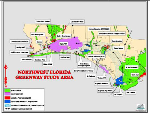
A consortium of private interests and public agencies is studying some of the region's open space with two uses in mind. This group wants to preserve land for conservation and reserve airspace for military training and testing.

The proposed Northwest Florida Greenway would stretch from
Eglin Air Force Base in the west to the Apalachicola National Forest in the east
The proposed Northwest Florida Greenway Project covers some 750,000 acres in a 100-mile-long swath across six counties. The proposed corridor will help to protect the region's renowned biodiversity while providing a place for military training and testing.
The first official step in the project was taken In November 2003, Governor Jeb Bush signed a “Memorandum of Partnership” with the U.S. Department of Defense, the Florida Department of Environmental Protection, and The Nature Conservancy. In July 2004, the partnership was expanded to include two federal agencies (the U.S. Fish and Wildlife Service and the U.S. Forest Service), three state agencies (the Department of Community Affairs, the Department of Agriculture and Consumer Affairs, and the Florida Fish and Wildlife Conservation Commission), the Northwest Florida Water Management District, and Okaloosa County.
Florida Forest Stewardship Program
The Florida Division of Forestry's Forest Stewardship Program is for people who own at least 25 acres of forested land. Owners of adjacent smaller acreages can combine their holdings in one application. From the program's website:
BENEFITS TO LANDOWNERS
Landowners will receive:
For more information, contact your county forester through your county's Agricultural Extension office.
Protecting Private Lands
Especially in other more urbanized areas, there has been increasing interest in protecting and setting aside private lands for open space. This may be done fairly easily if you are a large land owner (e.g., through the Forest Stewardship Program if you have more than 25 acres of forested land) but is not as straightforward in other instances.
Private lands can be protected through:
Note: The content of the website has not been updated since 2005. The site remains online for it's value as legacy content and is unlikely to be updated.