
Spatial Analysis and Planning
As a repository for information on Florida's Conservation Lands and rare species, FNAI is uniquely suited for conduct the large scale spatial analyses important to landscape level decision makers.
Examples:
-
Natural resource mapping and prioritization
- Florida ForeverSite Assessments
-
Species habitat and predictive distribution modeling
- FNAI is currently developing predicted habitat distribution models using MAXENT and Random Forest approaches to inform US Fish and Wildlife Service Species Status Assessment (SSA).
- We worked with NatureServe, in cooperation with ESRI and Microsoft, to develop the national Map of Biodiversity Importance (MoBI). MoBI is a collaborative predicted habitat modeling project intended to to identify the places most important for conserving at-risk species.
- More information about the Florida MOBI here
-
Land cover classification and analysis
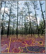
- Longleaf Databases - FNAI is working with partners to develop a comprehensive map of documented longleaf pine occurrences and ecological conditions across the range.
- Cooperative Landcover Map - FNAI and its partners are working to develop a single statewide land cover map based on best available data that has broad support and can be used by a diverse group of planners and managers.
-
Reserve design
- Florida Forever F-TRAC acquisition project prioritization process
- Decision support data and tools
- CLIP - CLIP is a GIS database of statewide conservation priorities for a broad range of natural resources, including biodiversity, landscape function, surface water, groundwater, and marine resources.
- Florida Forever Conservation Needs Assessment
- Land management review and planning
- FNAI scientists provide expert input on rare species and natural community management issues in the management plans for Florida conservation lands as part of the statutory plan review process.