The Florida Natural Areas Inventory (FNAI) has extensive experience monitoring invasive species and their impacts on Florida's rare species and ecosystems. FNAI can conduct a variety of invasive species surveys, management reviews, species distribution modeling, and training workshops to assist land managers. See some examples below.
We utilize transects, random sampling points, survey grids or permanent photo plots to map baseline presence data, determine population sizes, and prioritize treatment area.
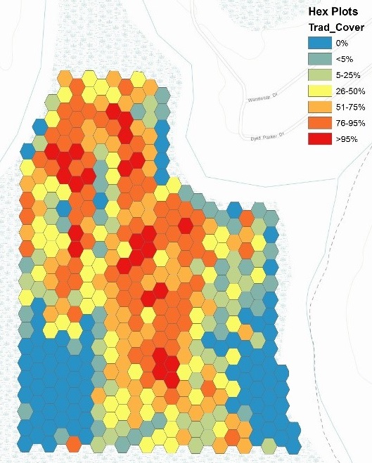
Example: We surveyed bottomland forest to record pre-treatment infestation cover for the invasive plant small-leaf spiderwort (Tradescantia fluminensis) for a pilot treatment project. Using a network of 422 hexagons (20m interior radius) for rapid surveying, this project took two surveyors two days to assess the entire 130 acre project site. This method captures the variability of cover of the target species in the project area.
We have standard protocols to survey for invasive plant treatment projects conducted by contractors, ensuring both coverage of treatment area and control of target species is adequate.
FNAI staff can perform early detection rapid response (EDRR) surveys, baseline surveys to determine the distribution and coverage of invasive plants, and post-treatment invasive plant surveys to document efficacy of invasive plant treatments and quantify improvements on the landscape. We can also provide a recommended management plan for the invasive plant species observed within the survey area. See example reports below:
We create invasive plant monitoring programs to assess invasive cover and determine the effectiveness of land management practices. We can also provide support on other invasives management topics including: integrating invasive species management with other land management activities, planning use of in-house staff vs. contractors in treating invasive plant populations, and the use of data collection apps to survey for invasive plant species or assess efficacy of control projects. Contact Dexter Sowell for more information.
We can provide a day-long training workshop to educate participants how to identify invasive plant species from similar looking native species. We can also provide participants a workshop that shows typical signs of decline of plants due to herbicide application, and tips to assessing effectiveness of an herbicide treatment project.
Informational pages about the various invasives found in the state of Florida

© 2020-2024 - Florida Natural Areas Inventory. We follow Florida State University's Privacy Policy
